Follow up rain-storms Nov 26-29th.
Page 27 of 35 •  1 ... 15 ... 26, 27, 28 ... 31 ... 35
 ![]()
Re: Follow up rain-storms Nov 26-29th.
![]() dagget Sat Nov 28, 2009 6:48 am
dagget Sat Nov 28, 2009 6:48 am
dagget- Posts : 160
Join date : 2009-06-30
Age : 51
Location : Woodend
Re: Follow up rain-storms Nov 26-29th.
![]() typhoon29 Sat Nov 28, 2009 7:10 am
typhoon29 Sat Nov 28, 2009 7:10 am

typhoon29- Posts : 73
Join date : 2009-06-13
Age : 45
Location : Ballarat (Brown Hill)
Re: Follow up rain-storms Nov 26-29th.
![]() Sniper Sat Nov 28, 2009 7:16 am
Sniper Sat Nov 28, 2009 7:16 am
Sniper- Posts : 652
Join date : 2009-06-12
Age : 46
Location : Doncaster East - 133 asl -

Re: Follow up rain-storms Nov 26-29th.
![]() Sniper Sat Nov 28, 2009 7:57 am
Sniper Sat Nov 28, 2009 7:57 am
Anything to report DarkEye?
Sniper- Posts : 652
Join date : 2009-06-12
Age : 46
Location : Doncaster East - 133 asl -
Re: Follow up rain-storms Nov 26-29th.
![]() Karl Lijnders Sat Nov 28, 2009 8:02 am
Karl Lijnders Sat Nov 28, 2009 8:02 am

Karl Lijnders- Posts : 1472
Join date : 2009-05-17
Age : 39
Location : Knoxfield, Victoria
Re: Follow up rain-storms Nov 26-29th.
![]() Karl Lijnders Sat Nov 28, 2009 8:04 am
Karl Lijnders Sat Nov 28, 2009 8:04 am
Australian Government Bureau of Meteorology
Victoria
Fire Weather Briefing for Victoria
Issued at 10:45 am EDT on Saturday 28 November 2009.
Estimates Today:
The fire weather estimates look good. The main possible difference is
thunderstorm potential in the west today. There could be a bit more widespread
thunderstorm rains in the southern Wimmera District if the storms gain strength
in the afternoon. Wind already quite fresh over much of the state due to the
position of the low pressure in the west. A wind change arrives overnight,
which is expected to clear central districts Sunday morning.
Observational Network Status:
Western Port is offline, as is Mt Baw Baw.
Weather Situation:
A low pressure system situated to the southwest of Victoria will move eastwards
overnight, reaching the Tasman Sea Sunday morning. On Monday a high will move
from the Bight towards southern Tasmania and will still lie near southern
Tasmania on Tuesday as the low drifts slowly eastwards across the Tasman Sea.
24 Hour Rainfall to 9am:
Widespread rainfall across much of central and western Victoria. Totals of
between 5 and 13mm were recorded at a number of reporting stations. Very little
rainfall over lower elevations of the Northeast and East Gippsland.
Weather Today:
Isolated showers and thunderstorms in the east clearing this morning, but
further showers and possible thunderstorms redeveloping from the west during
the day. Cool to mild with generally fresh northwest winds.
Karl Lijnders- Posts : 1472
Join date : 2009-05-17
Age : 39
Location : Knoxfield, Victoria
Re: Follow up rain-storms Nov 26-29th.
![]() Karl Lijnders Sat Nov 28, 2009 8:20 am
Karl Lijnders Sat Nov 28, 2009 8:20 am
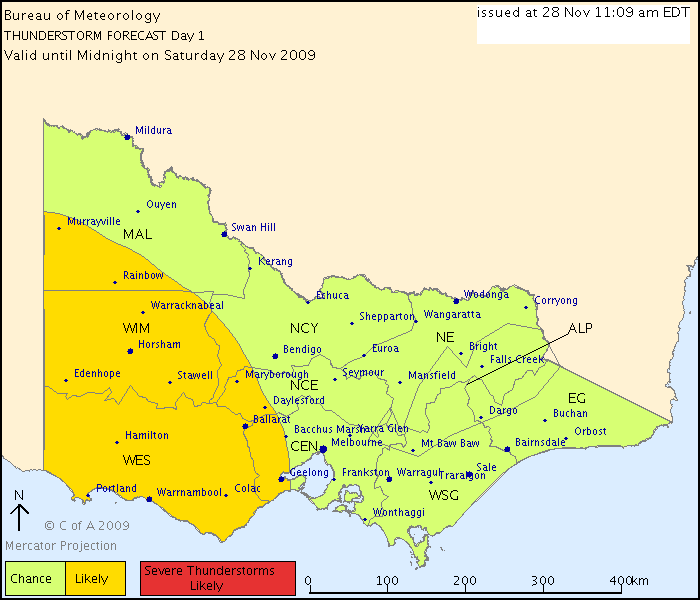
Victoria Regional Office
THUNDERSTORM FORECAST
Issued at 11:09 am Saturday, 28 November 2009,
Valid until midnight on Saturday, 28 November 2009.
Thunderstorms are possible throughout Victoria at various times today.
The most likely area is in the western part of the state associated with an upper cold pool, heavy showers are already occurring in this area. This cold pool is expected to move slowly east during the day, reaching the east at night. Damaging wind gusts and large hail are a small possibility with these thunderstorms.
Thunderstorms are also possible in East Gippsland ahead of a cold front which should clear the state in the next few hours.
Karl Lijnders- Posts : 1472
Join date : 2009-05-17
Age : 39
Location : Knoxfield, Victoria
Re: Follow up rain-storms Nov 26-29th.
![]() Sniper Sat Nov 28, 2009 8:22 am
Sniper Sat Nov 28, 2009 8:22 am
We're a shoe in to cop a storm now!!!
Sniper- Posts : 652
Join date : 2009-06-12
Age : 46
Location : Doncaster East - 133 asl -
Re: Follow up rain-storms Nov 26-29th.
![]() droughtbreaker Sat Nov 28, 2009 8:37 am
droughtbreaker Sat Nov 28, 2009 8:37 am
hillybilly wrote:Just 2.6mm down here in Sandy Point so a dud (pretty much as expected). Looks like about the same in Ferny Creek. Did hear any thunder.
The radar should be interesting from late morning on.
It's very interesting atm.
8.8mm here in the end. Without actually adding it up we'd be on around 93mm for the month now. Should be another 15-20mm here for the weekend. I'm liking the look of the SE flow developing late Sunday and throughout Monday. We still have a warm bay averaging around 20C and precipitable water remains healthy considering the cooler air mass.
droughtbreaker- Posts : 640
Join date : 2009-05-17
Age : 42
Location : Mount Macedon (520m asl)
Re: Follow up rain-storms Nov 26-29th.
![]() Karl Lijnders Sat Nov 28, 2009 8:42 am
Karl Lijnders Sat Nov 28, 2009 8:42 am
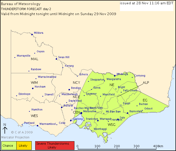
Victoria Regional Office
DAY 2 THUNDERSTORM FORECAST
Issued at 11:16 am Saturday, 28 November 2009,
Valid from midnight tonight until midnight on Sunday, 29 November 2009.
Thunderstorms associated with a cold pool moving east from Saturday are possible in the eastern parts of Victoria tomorrow. Note that this forecast is from midnight Sunday. During the day, thunderstorms are only expected in an area east of a line from Wilsons Promontory to Wodonga.
Karl Lijnders- Posts : 1472
Join date : 2009-05-17
Age : 39
Location : Knoxfield, Victoria
Re: Follow up rain-storms Nov 26-29th.
![]() Melbourne Skywalker Sat Nov 28, 2009 8:48 am
Melbourne Skywalker Sat Nov 28, 2009 8:48 am
Wind has really picked up out there.
Melbourne Skywalker- Posts : 154
Join date : 2009-06-17
Location : Burnside Heights
Re: Follow up rain-storms Nov 26-29th.
![]() norfolk Sat Nov 28, 2009 8:51 am
norfolk Sat Nov 28, 2009 8:51 am
norfolk- Posts : 413
Join date : 2009-05-19
Age : 48
Location : Caroline Springs
Re: Follow up rain-storms Nov 26-29th.
![]() Anthony Violi Sat Nov 28, 2009 9:06 am
Anthony Violi Sat Nov 28, 2009 9:06 am
And an amazing latest visual sat pic for Victoria...widespread convection ahead of the trough.
Last edited by Anthony Violi on Sat Nov 28, 2009 9:09 am; edited 1 time in total

Anthony Violi- Posts : 256
Join date : 2009-05-17
Age : 50
Location : Lilydale, Melbourne
Re: Follow up rain-storms Nov 26-29th.
![]() droughtbreaker Sat Nov 28, 2009 9:08 am
droughtbreaker Sat Nov 28, 2009 9:08 am
droughtbreaker- Posts : 640
Join date : 2009-05-17
Age : 42
Location : Mount Macedon (520m asl)
Re: Follow up rain-storms Nov 26-29th.
![]() norfolk Sat Nov 28, 2009 9:14 am
norfolk Sat Nov 28, 2009 9:14 am
norfolk- Posts : 413
Join date : 2009-05-19
Age : 48
Location : Caroline Springs
Re: Follow up rain-storms Nov 26-29th.
![]() Power Storm Sat Nov 28, 2009 9:48 am
Power Storm Sat Nov 28, 2009 9:48 am
EDIT - Just noticed as well that the BoM have a LAL of 2 for the western district.
Power Storm- Posts : 703
Join date : 2009-05-18
Age : 30
Location : Simpson South -
Re: Follow up rain-storms Nov 26-29th.
![]() droughtbreaker Sat Nov 28, 2009 10:00 am
droughtbreaker Sat Nov 28, 2009 10:00 am
norfolk wrote:it's mostly sunny here, thats why it feels much warmer than what it really is
22C in Melbourne so I'd agree with you Tony that is a nice temperature and would feel quite warm.
Showers only an hour or two away I'd say judging from the satellite, but the satellite is not quite the same thing as the radar is it.
droughtbreaker- Posts : 640
Join date : 2009-05-17
Age : 42
Location : Mount Macedon (520m asl)
Re: Follow up rain-storms Nov 26-29th.
![]() droughtbreaker Sat Nov 28, 2009 10:02 am
droughtbreaker Sat Nov 28, 2009 10:02 am
It's a real dud radar but it will do for now.
droughtbreaker- Posts : 640
Join date : 2009-05-17
Age : 42
Location : Mount Macedon (520m asl)
Re: Follow up rain-storms Nov 26-29th.
![]() droughtbreaker Sat Nov 28, 2009 10:19 am
droughtbreaker Sat Nov 28, 2009 10:19 am
droughtbreaker- Posts : 640
Join date : 2009-05-17
Age : 42
Location : Mount Macedon (520m asl)
Re: Follow up rain-storms Nov 26-29th.
![]() Karl Lijnders Sat Nov 28, 2009 10:31 am
Karl Lijnders Sat Nov 28, 2009 10:31 am
NW winds are as strong as a winters day here!!
Karl Lijnders- Posts : 1472
Join date : 2009-05-17
Age : 39
Location : Knoxfield, Victoria
Re: Follow up rain-storms Nov 26-29th.
![]() Karl Lijnders Sat Nov 28, 2009 10:48 am
Karl Lijnders Sat Nov 28, 2009 10:48 am
Karl Lijnders- Posts : 1472
Join date : 2009-05-17
Age : 39
Location : Knoxfield, Victoria
Re: Follow up rain-storms Nov 26-29th.
![]() Power Storm Sat Nov 28, 2009 11:02 am
Power Storm Sat Nov 28, 2009 11:02 am
Power Storm- Posts : 703
Join date : 2009-05-18
Age : 30
Location : Simpson South -
Re: Follow up rain-storms Nov 26-29th.
![]() Sniper Sat Nov 28, 2009 11:06 am
Sniper Sat Nov 28, 2009 11:06 am
Sniper- Posts : 652
Join date : 2009-06-12
Age : 46
Location : Doncaster East - 133 asl -
Re: Follow up rain-storms Nov 26-29th.
![]() Karl Lijnders Sat Nov 28, 2009 11:08 am
Karl Lijnders Sat Nov 28, 2009 11:08 am
Karl Lijnders- Posts : 1472
Join date : 2009-05-17
Age : 39
Location : Knoxfield, Victoria
Re: Follow up rain-storms Nov 26-29th.
![]() DarkEye Sat Nov 28, 2009 11:33 am
DarkEye Sat Nov 28, 2009 11:33 am

DarkEye- Posts : 52
Join date : 2009-06-30
Location : Portland, VIC -
Page 27 of 35 • 1 ... 15 ... 26, 27, 28 ... 31 ... 35 ![]()
» South Australia: Severe storms and Rain event 21/9
» Follow-up Rain (Low and Fronts): July 10-14 2009.
» Victoria: Significant Cold Outbreak - September 25th-29th 2009
» Brisbane Storms 7 September 2009
|
|
|