ENSO & IOD
+6
hillybilly
Malleefarmer
Karl Lijnders
droughtbreaker
Power Storm
Johnno
10 posters
Page 3 of 4
Page 3 of 4 •  1, 2, 3, 4
 Re: ENSO & IOD
Thanks guys.
Not exactly on topic, but I thought I would post this here as well as in the fire weather section...
-------
From, http://www.bushfirecrc.com/news/releases/outlook0910.html
Victoria
Above normal fire potential is expected for all of Victoria; a result of a persistent long-term rainfall deficit over the state. Forested areas in the Dandenong Ranges, Otway Ranges, the Grampians, the Macedon–Bendigo corridor, East Gippsland, and the water catchments of Melbourne are areas of particular concern. In all regions an early start to the fire season is likely. While recent rainfall totals in many areas of the state have been about average, it is not expected to mitigate the longer-term drying in the state.
------------
 Re: ENSO & IOD
I think you'll find that state and federal governments, local government, local and state fire authorities and any other organisations or groups associated with bushfire research etc. will always talk up the threat of bushfire regardless of likely conditions. This is basically to stir people into action to prepare themselves for the fire season because a lot of people become complacent. Almost every summer sees weather that is conducive to fire outbreaks and, at the very least, a few days that are severe. (eg. high 30s, gusty wind, very low RH%).
Personally I haven't heard anyone from the BOM, or anyone on here suggest that this summer will be any more severe than any other summer. There is no real indication at all that this year will be anything out of the ordinary. Very interesting to hear about the La Nina/severe heat outbreak link. I always suspected the extreme temps down here on 'Black Saturday' and other occasions in January also, were linked to the unusually intense and extreme monsoon season that the northern half of the country experienced. Indeed it seems the QLD flooding and SE heatwaves were linked and very intense monsoons up north lead to an outflow of extreme hot and dry air down here, I guess it also has something to do with all the tropical moisture getting locked into and used up by the intense monsoon trough leaving us with dessicated air and an extreme buildup of heat in the interior due to a lack of tropical airmass incursions below the tropical areas. Just my theory there though.
I actually reckon we will see more easterly winds this summer and a higher frequency of tropical moisture incursions leading to a better storm season for us and less heat buildup through the interior with generally more cloud building through there. Still I would be just guessing.
Certainly the remainder of October looks like a classic summer pattern to me arriving a couple of months early and is not encouraging at all given this system being a bit of a flop, basically means we have just a third or thereabouts of the monthly average here to date and much less through many other parts of the state. The good rainfall of August/September could soon become a distant memory. Hopefully though it breaks down again in November. Climate is all about variation and we have been due for a ridging, high dominating pattern for some time now.
droughtbreaker- Posts : 640
Join date : 2009-05-17
Age : 42
Location : Mount Macedon (520m asl)
 Re: ENSO & IOD
This enso event is certainly a weird one. It seem that the northern hemisphere is in el nino but the southern hemisphere refuses to co-operate. I've noticed when SSt in the pacific near the tip of south america are cool high pressure tends to dominate and strengthen the humbolt current. When the SSts are warm there the Nino 1+2 regions tend to warm up. I also wonder if there's some 18 year lunar cycle that affects the humbolt current through tidal effects 
For australian rainfall the current warm (-IOD) north west and cold south west SST's seems ideal. Highs are sitting off WA instead of over the south east and lows are forming over the north west and drifting through central aus towards us.
The highs also seem to form in the descending air of the monsoon trough. Last year the Monsoon sat over Aus for ages creating a constant ridge across australia that led to the horrendous heat build up and drought. The previous years bad weather seemed related to a trough off vanuatu causing a high to sit over the southeast. Personally i would like to see the MOJO go round nice and quickly rather than getting stuck in one spot like lately!
windyrob- Posts : 59
Join date : 2009-08-15
Age : 46
Location : Hawthorn
 Re: ENSO & IOD
Latest indicators are a bit worrying with a sudden swing to classic El Nino with the western Pacific cooled right down with solid negative SST anomalies and the long term SOI trends just getting into the negatives now. Also these cool anomalies are flowing through to the eastern Indian with a +ve IOD look about things. We see this rapid shift in conditions with the El Nino finally starting to have an impact and now suddenly we have a strong ridging setup with the highs over the SE of the continent and some rather persistent heat set to be dragged down almost on cue.
Hopefully now that we are transitioning out of spring and towards summer the relationship between ENSO indicators and our actual weather here will weaken as it usually does around December and January. Other factors still seem to be pointing towards the El Nino pattern breaking down into next year and hopefully it will be just in time for normal Autumn rains to commence.
Hopefully now that we are transitioning out of spring and towards summer the relationship between ENSO indicators and our actual weather here will weaken as it usually does around December and January. Other factors still seem to be pointing towards the El Nino pattern breaking down into next year and hopefully it will be just in time for normal Autumn rains to commence.
droughtbreaker- Posts : 640
Join date : 2009-05-17
Age : 42
Location : Mount Macedon (520m asl)
 Re: ENSO & IOD
Just wondering if you can clarify something DJ.. Is it true few months ago you said that in an El Nino Summer (In a weakening mode of course) that it isn't normally as hot down here due to more frequent SW winds so therefore not that hot? And La Nina Summers you can have blocks therefore more NE to N winds with more rain up the east coast and heatwaves down here? Think it might go again this way this Summer with perhaps a milder Summer? POAMA suggests normal average temps and rainfall does it? At least for December and January at the moment for down here
Johnno- Posts : 741
Join date : 2009-05-18
Age : 46
Location : Near the Showgrounds
 Re: ENSO & IOD
hillybilly wrote:First thing to remember is that global warming is changing everything - the source region for our heatwave (about 20S) is warming up rather quickly (http://www.bom.gov.au/cgi-bin/climate/change/trendmaps.cgi?map=tmean&area=aus&season=0112&period=1970). It's a noise trend, but essentially now we have air that is frequently extremely hot ready to dive south.
You actually find that El Nino summers are usually "cooler than average" but have a small number of very dry very hot windy days. In contrast, La Nina summers are usually "warmer than average" but most usually lack very dry hot windy days. La Nina summers tend to have a lot of northeasterlies and El Nina summers tend to have a lot of southwesterlies. This is in the average - however - as I'll explain below...
As it turns out the two hottest spells in Victoria's history - 1939 and 2009 were both La Nina summers. These were both characterised by a extended block with little change in air mass. I suspect there is a bit of sting in the tail of the northeasterly pattern common in La Nina. The La Nina pattern means the summers are often very blocked and occasionally these blocks lead to the build up of extreme heat.
That's the post you were looking for John.
droughtbreaker- Posts : 640
Join date : 2009-05-17
Age : 42
Location : Mount Macedon (520m asl)
 Re: ENSO & IOD
Does anyone know what effect west pacific typhoons have on El nino's. On one hand they would seem to cause westerly wind bursts but on the other they represent low pressure and increased convection! I wonder if thats why el ninos get going during our autumn, before the northern typhoon season gets going?

windyrob- Posts : 59
Join date : 2009-08-15
Age : 46
Location : Hawthorn
 Re: ENSO & IOD
We may be seeing the effect of classic el niño conditins but reserved for QLD and NSW which have both had dry and windy winters after very wet starts. The westerly may not be finished here yet with signs of it returning next week which is a sign that el niño is increasing. Good for rainfall here but shocking for fires in the eastern states.

Karl Lijnders- Posts : 1472
Join date : 2009-05-17
Age : 39
Location : Knoxfield, Victoria
 Re: ENSO & IOD
Interesting that the SOI is falling fast (down to about -5) and the central Pacific has warmed rapidly due to strong westerly winds (http://www.pmel.noaa.gov/tao/jsdisplay/plots/gif/sst_wind_anom_5day_ps32.gif). It certainly doesn't look like a normal El Nino pattern, but it is a shift more towards El Nino.
The worry is that we have seen a shift to drier conditions in the southeast which will continue through the remainder of spring. Usually during El Nino events things start to dry out in the southeast during spring - autumn/winter can be a mixed bag but by spring the dry almost always becomes established at some point. At this stage October could still be a shocker for Vic if we don't get another rain event .
.
Further north the dry conditions in NSW and QLD have been very typical El Nino.
The worry is that we have seen a shift to drier conditions in the southeast which will continue through the remainder of spring. Usually during El Nino events things start to dry out in the southeast during spring - autumn/winter can be a mixed bag but by spring the dry almost always becomes established at some point. At this stage October could still be a shocker for Vic if we don't get another rain event
 .
.Further north the dry conditions in NSW and QLD have been very typical El Nino.
 Re: ENSO & IOD
NSW and Qld may get their share over the coming week if EC and GFS have anything to do with it DJ and October may end up being a wet month for alot of them up there but to be honest I'm not so sure it will develop as EC and GFS suggest as other models aren't really onboard
Johnno- Posts : 741
Join date : 2009-05-18
Age : 46
Location : Near the Showgrounds
 Re: ENSO & IOD
That rainfall map is a bit misleading for up here, I guess due to a lack of reporting rainfall gauges. We have had 51mm here so far this month and that is actually 66% of the current October mean for my place with around 34 years of records. The last three Octobers have all seen rainfall less than 20mm (crazy  ) so the average has actually gone down dramatically purely thanks to that, but still I'd say we are at least 57% of the monthly mean even if you disregard the last few years. I couldn't say, even if we don't get another drop of rain this month, that is has been a very dry month, just a standard dry month.
The main thing we need to remember is that systems can evolve and patterns can change very quickly. I'm sure there have been heaps of occasions where there have been extended dry spells in a month but one event at the end of the month makes up the numbers. Also November could still be wet even if the rest of October is rainless. I understand why everyone is so concerned, I'm concerned too by the latest pattern change but it is not at all unusual IMO.
The main thing we need to remember is that systems can evolve and patterns can change very quickly. I'm sure there have been heaps of occasions where there have been extended dry spells in a month but one event at the end of the month makes up the numbers. Also November could still be wet even if the rest of October is rainless. I understand why everyone is so concerned, I'm concerned too by the latest pattern change but it is not at all unusual IMO.
droughtbreaker- Posts : 640
Join date : 2009-05-17
Age : 42
Location : Mount Macedon (520m asl)
 Re: ENSO & IOD
That rainfall map is a bit misleading for up here, I guess due to a lack of reporting rainfall gauges.
Andrew the map is against the 1961-1990 average which might explain the difference. It is also based on a 25km grid which will smooth out some detail, particularly where altitude has played a role. In the Dandenongs it's a mixed bag. The southern Dandenongs have had a shocking October - about 60mm - which is 50% of average. The area around Olinda has had close to 100mm which is about 80% of average so "almost" average.
The months rainfall has tended to be in shower bands/storms which have tended to form streets meaning some areas have been dumped on while near neighbours have missed out.
BTW I suspect Melbourne's Jan->Oct total could be a record low. The city has had a shocking shocking year....
 Re: ENSO & IOD
Tomorrow the BOM's 3 months rainfall outlook chances and temps are out predicting from November to January and going by history I would say be similar to what was forecasted in 2002 and 2006 (both El Ninos yrs similar ocean temps to now) for the November to January periods? Why do I say this? Going by history came across this....
Rainfall outlook 2002 Oct to Dec..
http://www.bom.gov.au/announcements/media_releases/climate/ahead/20020917R.shtml
Rainfall outlook 2006 Oct to Dec..
http://www.bom.gov.au/announcements/media_releases/climate/ahead/20060926R.shtml
Rainfall outlook 2009 Oct to Dec...
http://www.bom.gov.au/climate/ahead/archive/rainfall/20090922.shtml
Anyone else see an almost identical forecast? I certaintly do for most of Australia and especially Victoria... Almost a cut and paste job but I'm sure BOM have their reasons (Mainly El Nino)
Now heres tempertures for the same period October to December
2002.. http://www.bom.gov.au/announcements/media_releases/climate/ahead/20020917T.shtml
2006.. http://www.bom.gov.au/announcements/media_releases/climate/ahead/20060926T.shtml
2009..
http://www.bom.gov.au/climate/ahead/archive/temperature/20090922.shtml
Once again preety much mirror image hey!
Heres the rainfall chances now forecasted for November to January 2002/03 & 2006/07..
http://www.bom.gov.au/announcements/media_releases/climate/ahead/20021016R.shtml
http://www.bom.gov.au/announcements/media_releases/climate/ahead/20061026R.shtml
Once again another mirror image!
And Tempertures for the same period (Nov to Jan 2002/03 & 2006/07)
http://www.bom.gov.au/announcements/media_releases/climate/ahead/20021016T.shtml
http://www.bom.gov.au/announcements/media_releases/climate/ahead/20061026T.shtml
Very very similar once again.. Therefore My point and question is is it fair to say tomorrows outlook for Nov to Jan be any different comparing to the same period Nov to Jan of those years?? If I were a betting man I would say NO I expect a very similar rainfall and temp outlook again to those 2 years tomorrow and if not then I'm the one thats going to look like a stooge hey
Johnno- Posts : 741
Join date : 2009-05-18
Age : 46
Location : Near the Showgrounds
 Re: ENSO & IOD
Well I thought I might be eating humble pie today but it seems I am right on the mark.. The lastest 3 months rainfall and temps outlook is out for November 2009 to January 2010 and true to form they are an almost exact replica of Nov to Jan 2002/03 and 2006/07
Heres is rainfall outlook for 2002/03 Nov to Jan....
http://www.bom.gov.au/announcements/media_releases/climate/ahead/20021016R.shtml
2006/07 Nov to Jan...
http://www.bom.gov.au/announcements/media_releases/climate/ahead/20061026R.shtml
And now 2009/10 Nov to Jan...
http://www.bom.gov.au/climate/ahead/rain_ahead.shtml
The trend continues of the 3 years BOM progging the chances of rainfall very similar.
And temps outlook...
2002/03 Nov to Jan...
http://www.bom.gov.au/announcements/media_releases/climate/ahead/20021016T.shtml
2006/07 Nov to Jan...
http://www.bom.gov.au/announcements/media_releases/climate/ahead/20061026T.shtml
And now 2009/10 Nov to Jan..
http://www.bom.gov.au/climate/ahead/temps_ahead.shtml
Once again all very similar with only the Min temps of 2006/07 being slightly different the chances of SW WA.
Going by history then I would expect BOM next edition next month Dec to Feb (Summer) rainfall and temp outlook then for them to expect close to neutral temps and rainfall..
2002/03 Dec to Feb rainfall outlook...
http://www.bom.gov.au/announcements/media_releases/climate/ahead/20021115R.shtml
2006/07 Dec to Feb rainfall outlook...
http://www.bom.gov.au/announcements/media_releases/climate/ahead/20061123R.shtml
And temps..
2002/03 Dec to Feb temps outlook...
http://www.bom.gov.au/announcements/media_releases/climate/ahead/20021115T.shtml
2006/07 Dec to Feb temps outlook...
http://www.bom.gov.au/announcements/media_releases/climate/ahead/20061123T.shtml
Once again similar and I expect the next outlook late November for Summer to be little different to these.
John.
Johnno- Posts : 741
Join date : 2009-05-18
Age : 46
Location : Near the Showgrounds
 Re: ENSO & IOD
Nice recap John 
I think the next sequence of weather will be telling. The easterly winds are moving south over the northern part of Aus and we wave goodbye to the westerly winds. This forces high pressure south for a while as things settle into summer time and troughs and lows start forming over the interior. Transition times. It is how we evolve out of it that will be key.
I think there will be something towards the end of the run which may be 5-10mm but a more significant weather event may be about 21 days away as things start winding up into that summer pattern.
Interesting that the areas that are forecast to be drier than normal are going to enjoy some above average rainfall. El Nino is not what it used to be it seems

Karl Lijnders- Posts : 1472
Join date : 2009-05-17
Age : 39
Location : Knoxfield, Victoria
 Re: ENSO & IOD
I would like to also say thanks to John for putting that information up. I would have had no idea where to find past 3 month outlooks, and the stuff and info that you have posted is well worth looking at mate.. Thanks for posting that up, and what an interesting pattern the BoM seem to be following.... 
 Re: ENSO & IOD
Thanks guys. Its in the media archives Jake on the top right hand corner on the home BOM page.
Came across this..
Bushfires in southeastern Australia linked to Indian Ocean Dipole events
http://www.agu.org/cgi-bin/highlights/highlights.cgi?action=show&doi=10.1029/2009GL039902&jc=gl
Came across this..
Bushfires in southeastern Australia linked to Indian Ocean Dipole events
http://www.agu.org/cgi-bin/highlights/highlights.cgi?action=show&doi=10.1029/2009GL039902&jc=gl
Johnno- Posts : 741
Join date : 2009-05-18
Age : 46
Location : Near the Showgrounds
 Re: ENSO & IOD
Big surge in the El Nino indices in the last week. The SOI has fallen through the floor 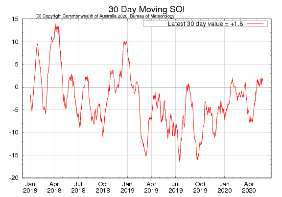 and the Pacific Ocean waters have risen sharply
 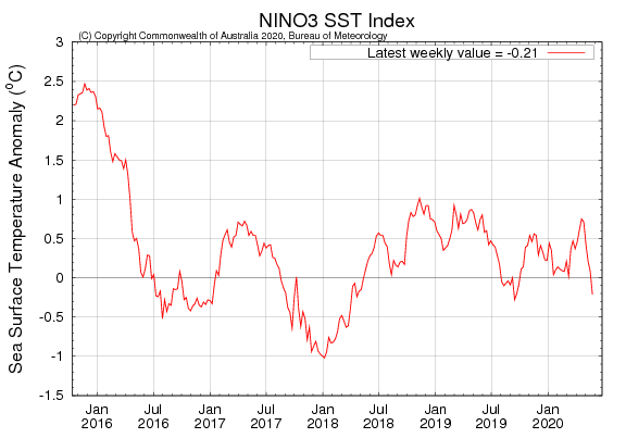 . Now certain that 2009 will go down as a significant El Nino year.
BTW why some might view this as "bad" it is actually a positive for the southeast in the longterm. This lurch into El Nino has been associated with the first cooling of the western Pacific which is the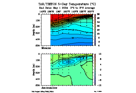 first step in the break down of the El Nino. Over the next few months we should see the cooler water slowly erode the El Nino event so that moving into autumn/winter next year the El Nino should be over (http://www.bom.gov.au/climate/coupled_model/poama.shtml).
That said, we can anticipate below average rainfall across much of eastern Australia in the coming months.
 and the Pacific Ocean waters have risen sharply
  . Now certain that 2009 will go down as a significant El Nino year.
BTW why some might view this as "bad" it is actually a positive for the southeast in the longterm. This lurch into El Nino has been associated with the first cooling of the western Pacific which is the
 first step in the break down of the El Nino. Over the next few months we should see the cooler water slowly erode the El Nino event so that moving into autumn/winter next year the El Nino should be over (http://www.bom.gov.au/climate/coupled_model/poama.shtml).
 That said, we can anticipate below average rainfall across much of eastern Australia in the coming months.
 Re: ENSO & IOD
Just a quickie comment on the gloom about Vic rainfall. Below is the rainfall for the last 3 months 
and here is the average winter/spring rainfall for historical El Nino years .
.
We have actually done pretty well - all things considering. To get average to above average rainfall (generally from June to end October) has been very lucky - we've done well. That said, Jan/Feb and May were horribly dry and some have missed out - particularly those living near Melbourne CBD and surrounding areas.
Of course, a hot dry Nov/Dec could turn things bad quickly... and we do have the long long drought underlying everything.

and here is the average winter/spring rainfall for historical El Nino years
 .
.We have actually done pretty well - all things considering. To get average to above average rainfall (generally from June to end October) has been very lucky - we've done well. That said, Jan/Feb and May were horribly dry and some have missed out - particularly those living near Melbourne CBD and surrounding areas.
Of course, a hot dry Nov/Dec could turn things bad quickly... and we do have the long long drought underlying everything.
 Re: ENSO & IOD
We have done extraordinarily well out here in the Yarra Valley, but that graph is a generalisation becuase there are some parts of Vic that havent had 20% of there average. And thats what makes this weather so puzzling. Certain pockets are receiving copious amounts of rain and others 50 kms away are recieving a fraction of that. In the past when we have had wet periods for several months the whole state does well but that has changed.

Anthony Violi- Posts : 256
Join date : 2009-05-17
Age : 50
Location : Lilydale, Melbourne
 Re: ENSO & IOD
Yeah A Neutral IOD helped this Winter and early Spring when you would normally get a Positive IOD associated with an El Nino meaning Cool waters NW of Oz which didn't happen this year.
Word getting out into parts of the public/media that this El Nino is a "Modoki El Nino" know much about it guys? Apparently it's the opposite to a normal El nino developing which is warm water upwelling from the East and spreading west along the equator where this time it has been the other way round but its all El Nino to me. In 1 way I wouldn't mind this El Nino being strong now the stronger it gets the more the breakdown will be once its weakens which could cause all sorts of weather next Autumn it alsos increases the chances of La Nina later next year. We all remember what happend in 1998 after the big strong El Nino of 1997/98 don't we? Yess 98 was a very warm year nationwise and globally as the lag effect lingered from the El Nino but as the Strong El Nino broke down alot of Australia saw above average rainfall that year so it was a warm and wet year for most of the nation so I am hopeing for something similar next year.
Word getting out into parts of the public/media that this El Nino is a "Modoki El Nino" know much about it guys? Apparently it's the opposite to a normal El nino developing which is warm water upwelling from the East and spreading west along the equator where this time it has been the other way round but its all El Nino to me. In 1 way I wouldn't mind this El Nino being strong now the stronger it gets the more the breakdown will be once its weakens which could cause all sorts of weather next Autumn it alsos increases the chances of La Nina later next year. We all remember what happend in 1998 after the big strong El Nino of 1997/98 don't we? Yess 98 was a very warm year nationwise and globally as the lag effect lingered from the El Nino but as the Strong El Nino broke down alot of Australia saw above average rainfall that year so it was a warm and wet year for most of the nation so I am hopeing for something similar next year.
Last edited by Johnno on Wed Nov 04, 2009 8:59 am; edited 1 time in total
Johnno- Posts : 741
Join date : 2009-05-18
Age : 46
Location : Near the Showgrounds
 Re: ENSO & IOD
Also the SOI as DJ has stated has fallen rapidily last 3 to 4 weeks and is now -17 and still falling which is lower than the 2002/03 and 2006/07 events on any given month of those years. Would it be fair to say even as now this El Nino would be classified as a Moderate to Strong event? the ssts structure seems warmer now than the 2006/07 El Nino which was classified as moderate and the 2002/03 El Nino
Johnno- Posts : 741
Join date : 2009-05-18
Age : 46
Location : Near the Showgrounds
 Re: ENSO & IOD
So with this El Nino does it look like it will continue into Summer and start breaking down around April time?
Looking at the weather over the next week it looks like a sign of things to come over the next few months
Looking at the weather over the next week it looks like a sign of things to come over the next few months
The Watto- Posts : 30
Join date : 2009-10-23
Location : Mentone
 Re: ENSO & IOD
Thats the biggest concern I have had about this Summer. The heat just dry's things out, it certainly looks like a warmer than average month or so ahead, many records to be broken no doubt. Even though some parts of Victoria have done really well, it does not take that much to turn it dry and bleak again, setting the state up for another major bushfire season. The soil below is still very dry, and it seems my area (bar the NW of the state) is the only parts of the state that have fire restrictions on currently! I still think we will have a good storm season right up till the end of Autumn from now (lets hope wet thunderstorms and not dry), but it does look like drier conditions developing.
Oh and John, I would say it would be classified as a strong El Nino now, despite its strange start.
Oh and John, I would say it would be classified as a strong El Nino now, despite its strange start.
 Re: ENSO & IOD
Watto - yes we would expect the El Nino to break down over summer into autumn. The breakdown can happen very quickly (such as in 2006) or can drag on into autumn. This is partly due to unpredictable weather - the 2006 break down was associated with a sustained surge in the trade winds.
Johnno I think the IOD really saved our bacon this year in the south. The pattern of rainfall for winter to now has been pretty classical El Nino with a neutral IOD. This pattern sees dry conditions through QLD/NSW but tending towards average across the south. It could have been a truly horrible year for all if this hadn't happened (though some areas were not so lucky such as around Melbourne which has experienced a horribly dry year).
BTW RE Modoki a lot of climate scientists don't buy the "modoki" idea - and I'm one of them. I think El Nino events come in all flavours and it makes little sense to try to give them one of two names ("modoki" or "normal/non-modoki") - I liken it to trying to summarise every summer/winter/spring/autumn as being "normal" or "abnormal" - makes no sense - every one is different. There is no need to simplify the "system" as climate models do not care about simple patterns - they take the current state of the ocean/atmosphere system and predict forwards in time capturing the full complexity.
Yeah A Neutral IOD helped this Winter and early Spring when you would normally get a Positive IOD associated with an El Nino meaning Cool waters NW of Oz which didn't happen this year.
Word getting out into parts of the public/media that this El Nino is a "Modoki El Nino" know much about it guys?
Johnno I think the IOD really saved our bacon this year in the south. The pattern of rainfall for winter to now has been pretty classical El Nino with a neutral IOD. This pattern sees dry conditions through QLD/NSW but tending towards average across the south. It could have been a truly horrible year for all if this hadn't happened (though some areas were not so lucky such as around Melbourne which has experienced a horribly dry year).
BTW RE Modoki a lot of climate scientists don't buy the "modoki" idea - and I'm one of them. I think El Nino events come in all flavours and it makes little sense to try to give them one of two names ("modoki" or "normal/non-modoki") - I liken it to trying to summarise every summer/winter/spring/autumn as being "normal" or "abnormal" - makes no sense - every one is different. There is no need to simplify the "system" as climate models do not care about simple patterns - they take the current state of the ocean/atmosphere system and predict forwards in time capturing the full complexity.
Page 3 of 4 •  1, 2, 3, 4
Page 3 of 4
Permissions in this forum:
You cannot reply to topics in this forum|
|
|
