Victoria: Traditional Winter Westerly #1. July 25th - August 5th 2009.
Page 5 of 8 •  1, 2, 3, 4, 5, 6, 7, 8
 ![]()
Re: Victoria: Traditional Winter Westerly #1. July 25th - August 5th 2009.
![]() Karl Lijnders Sat Aug 01, 2009 3:28 pm
Karl Lijnders Sat Aug 01, 2009 3:28 pm
Looking alright for a few mm into the catchment 5mm or so, and 2-3mm in the outer E and NE suburbs.
Should be a few showers off and on overnight.
Tomorrow looks OK with a nice NW wind developing, up to 80kmh later through Melbourne. I still think a fairly useful period of shower or rain activity for southern and mountain areas, with the exposed coasts fairing best. Up to 10mm likely through some southern and eastern suburbs of Melbourne with Melbourne itself likely to receive up to 5mm max.
Quite showery early Monday through the south and east but contracting south as the day goes on as winds tend more NNW again ahead of the next system. This system looks a little disappointing with the potential early on for a low level snow event. I think that has passed at this point in time and we may have to wait for later in the week into the weekend for that. Still another 5-10mm across southern areas out of this looks fair.
Beyond that we shift back into a vigorous NW/SW stream for Thurs/Fri with periods of showers and gale force winds. A brief respite with Saturday looking fine but those strong N winds developing again. Perhaps by weekends end there could be another major low/frontal system with periods of rain statewide. The south certainly looking quite soggy for the next week and cool to mild.

Karl Lijnders- Posts : 1472
Join date : 2009-05-17
Age : 39
Location : Knoxfield, Victoria
Re: Victoria: Traditional Winter Westerly #1. July 25th - August 5th 2009.
![]() DC449 Sat Aug 01, 2009 4:14 pm
DC449 Sat Aug 01, 2009 4:14 pm
DC449- Posts : 156
Join date : 2009-06-13
Age : 30
Location : Melbourne SE
Re: Victoria: Traditional Winter Westerly #1. July 25th - August 5th 2009.
![]() hillybilly Sun Aug 02, 2009 8:34 am
hillybilly Sun Aug 02, 2009 8:34 am
Not looking so great the next 24 hours now, though it still looks quite good for parts of the south - particularly the Yarra Ranges and south Gippsland, southwest coast with a decent burst of showers with the front (due later today). Expect about 5-10mm up here now overnight.
No obvious break in this pattern with EC, GAPS, UK and JMA continuing showers right through for the next 7-10 days. Fronts due on Sunday/Tuesday/Thursday/Saturday at this stage (though timing is tricky). Is a long time since I last remember such a protracted showery westerly up here - would guess a couple of years at least.
hillybilly- Posts : 742
Join date : 2009-05-18
Location : Ferny Creek -

Re: Victoria: Traditional Winter Westerly #1. July 25th - August 5th 2009.
![]() Karl Lijnders Sun Aug 02, 2009 2:46 pm
Karl Lijnders Sun Aug 02, 2009 2:46 pm
Checkng the 28 day rain outlook it could mean more falls everyday this month!! Literally!!!
Karl Lijnders- Posts : 1472
Join date : 2009-05-17
Age : 39
Location : Knoxfield, Victoria
Re: Victoria: Traditional Winter Westerly #1. July 25th - August 5th 2009.
![]() Power Storm Sun Aug 02, 2009 4:31 pm
Power Storm Sun Aug 02, 2009 4:31 pm
Still watching next weekend (Sunday), could be interesting, but I will be at the snow!!!
Power Storm- Posts : 703
Join date : 2009-05-18
Age : 30
Location : Simpson South -
Re: Victoria: Traditional Winter Westerly #1. July 25th - August 5th 2009.
![]() Johnno Sun Aug 02, 2009 6:00 pm
Johnno Sun Aug 02, 2009 6:00 pm
Johnno wrote:Nice showers here at the moment mabye close to 1mm
Way I see it DJ tomorrow looks ok but UK isn't really onboard with EC and never has been to this point which makes me wonder abit.
All models have downgraded for Tuesday however Thursday looks better we shall see how it pans out.
Once again it looks like UK was right all along. It amazes me how far more superior this model is than most others
Johnno- Posts : 741
Join date : 2009-05-18
Age : 46
Location : Near the Showgrounds
Re: Victoria: Traditional Winter Westerly #1. July 25th - August 5th 2009.
![]() droughtbreaker Sun Aug 02, 2009 7:39 pm
droughtbreaker Sun Aug 02, 2009 7:39 pm
It has been very windy here since mid afternoon. 9C atm but the wind chill is rather intense. Actually went for a bit of a walk at 5pm today in the thick of it and came back with earache, neck ache, toothache the works from the strong wind and bad wind chill.
droughtbreaker- Posts : 640
Join date : 2009-05-17
Age : 42
Location : Mount Macedon (520m asl)
Re: Victoria: Traditional Winter Westerly #1. July 25th - August 5th 2009.
![]() Karl Lijnders Sun Aug 02, 2009 9:33 pm
Karl Lijnders Sun Aug 02, 2009 9:33 pm
Karl Lijnders- Posts : 1472
Join date : 2009-05-17
Age : 39
Location : Knoxfield, Victoria
Re: Victoria: Traditional Winter Westerly #1. July 25th - August 5th 2009.
![]() James Sun Aug 02, 2009 9:35 pm
James Sun Aug 02, 2009 9:35 pm
i dont, but i think some heavy windy rain shortly but its moving pretty quick
James- Posts : 94
Join date : 2009-06-13
Location : Boronia
Re: Victoria: Traditional Winter Westerly #1. July 25th - August 5th 2009.
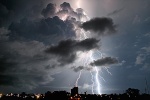
![]() Flangfest Sun Aug 02, 2009 11:02 pm
Flangfest Sun Aug 02, 2009 11:02 pm

Current Radar Image @ 1:00am. Not sure if anyone is up but lightning active. Interesting to see what happens when it hits.
Flangfest- Posts : 23
Join date : 2009-05-18
Age : 33
Location : Knoxfield
Re: Victoria: Traditional Winter Westerly #1. July 25th - August 5th 2009.
![]() James Sun Aug 02, 2009 11:09 pm
James Sun Aug 02, 2009 11:09 pm
James- Posts : 94
Join date : 2009-06-13
Location : Boronia
Re: Victoria: Traditional Winter Westerly #1. July 25th - August 5th 2009.
![]() James Sun Aug 02, 2009 11:39 pm
James Sun Aug 02, 2009 11:39 pm
James- Posts : 94
Join date : 2009-06-13
Location : Boronia
Re: Victoria: Traditional Winter Westerly #1. July 25th - August 5th 2009.
![]() SC Sun Aug 02, 2009 11:42 pm
SC Sun Aug 02, 2009 11:42 pm

SC- Posts : 105
Join date : 2009-06-12
Age : 56
Location : Notting Hill
Re: Victoria: Traditional Winter Westerly #1. July 25th - August 5th 2009.
![]() James Sun Aug 02, 2009 11:48 pm
James Sun Aug 02, 2009 11:48 pm
James- Posts : 94
Join date : 2009-06-13
Location : Boronia
Re: Victoria: Traditional Winter Westerly #1. July 25th - August 5th 2009.
![]() James Sun Aug 02, 2009 11:51 pm
James Sun Aug 02, 2009 11:51 pm
James- Posts : 94
Join date : 2009-06-13
Location : Boronia
Re: Victoria: Traditional Winter Westerly #1. July 25th - August 5th 2009.
![]() SC Sun Aug 02, 2009 11:52 pm
SC Sun Aug 02, 2009 11:52 pm
SC- Posts : 105
Join date : 2009-06-12
Age : 56
Location : Notting Hill
Re: Victoria: Traditional Winter Westerly #1. July 25th - August 5th 2009.
![]() James Sun Aug 02, 2009 11:55 pm
James Sun Aug 02, 2009 11:55 pm
James- Posts : 94
Join date : 2009-06-13
Location : Boronia
Re: Victoria: Traditional Winter Westerly #1. July 25th - August 5th 2009.
![]() Karl Lijnders Sun Aug 02, 2009 11:56 pm
Karl Lijnders Sun Aug 02, 2009 11:56 pm
10mm possible. Lightning continues over the east!!!
Karl Lijnders- Posts : 1472
Join date : 2009-05-17
Age : 39
Location : Knoxfield, Victoria
Re: Victoria: Traditional Winter Westerly #1. July 25th - August 5th 2009.
![]() SC Mon Aug 03, 2009 12:02 am
SC Mon Aug 03, 2009 12:02 am
SC- Posts : 105
Join date : 2009-06-12
Age : 56
Location : Notting Hill
Re: Victoria: Traditional Winter Westerly #1. July 25th - August 5th 2009.
![]() Australis(Shell3155) Mon Aug 03, 2009 12:36 am
Australis(Shell3155) Mon Aug 03, 2009 12:36 am

Australis(Shell3155)- Posts : 166
Join date : 2009-06-12
Location : Boronia
Re: Victoria: Traditional Winter Westerly #1. July 25th - August 5th 2009.
![]() hillybilly Mon Aug 03, 2009 5:28 am
hillybilly Mon Aug 03, 2009 5:28 am
Almost embarrassed to admit I slept through the whole thing - but must have been wild with branches all over the roads this morning and a big blackwood blocking the tourist road.... 5.4mm of rain (bit less that I had thought/hope) but a peak rain of 105mm/hr. Huge shame it didn't come through at 4pm on Sunday afternoon. Event total is now near 30mm and edging up.
BTW you can see the sequence at http://radar.strikeone.net.au/?fuseaction=loops.main&radar=023&numberofImages=10&dateStart=1249219200&dateFinish=1249244400 .
hillybilly- Posts : 742
Join date : 2009-05-18
Location : Ferny Creek -
Re: Victoria: Traditional Winter Westerly #1. July 25th - August 5th 2009.
![]() Karl Lijnders Mon Aug 03, 2009 5:47 am
Karl Lijnders Mon Aug 03, 2009 5:47 am
Looks like a good day out there. Back to a few showers tomorrow. Thursday could be the next interesting front.
Karl Lijnders- Posts : 1472
Join date : 2009-05-17
Age : 39
Location : Knoxfield, Victoria
Re: Victoria: Traditional Winter Westerly. July 25th - ??? 2009.
![]() tizza Mon Aug 03, 2009 5:52 am
tizza Mon Aug 03, 2009 5:52 am

tizza- Posts : 101
Join date : 2009-06-17
Age : 53
Location : Richmond, Melbourne
Re: Victoria: Traditional Winter Westerly #1. July 25th - August 5th 2009.
![]() DC449 Mon Aug 03, 2009 6:23 am
DC449 Mon Aug 03, 2009 6:23 am
DC449- Posts : 156
Join date : 2009-06-13
Age : 30
Location : Melbourne SE
Re: Victoria: Traditional Winter Westerly #1. July 25th - August 5th 2009.
![]() Dez Mon Aug 03, 2009 6:28 am
Dez Mon Aug 03, 2009 6:28 am
Dez- Posts : 84
Join date : 2009-07-22
Location : Taylors Lakes
Sponsored content
Page 5 of 8 • 1, 2, 3, 4, 5, 6, 7, 8 ![]()
» Victoria: Winter Averages and Rainfall 2009
» Victoria: Broad area of low pressure - November 19th-25th 2009.
» Victoria: Significant Cold Outbreak - September 25th-29th 2009
» Victoria: A week of fronts/lows for SE September 21st-24th 2009
|
|
|