Victoria: Thunderstorm Outbreak. October 28th-November 3rd 2009
Page 13 of 40 •  1 ... 8 ... 12, 13, 14 ... 26 ... 40
 ![]()
Re: Victoria: Thunderstorm Outbreak. October 28th-November 3rd 2009
![]() mick Fri Oct 30, 2009 4:29 pm
mick Fri Oct 30, 2009 4:29 pm
mick- Posts : 149
Join date : 2009-06-30
Location : down the bay
Re: Victoria: Thunderstorm Outbreak. October 28th-November 3rd 2009
![]() James Fri Oct 30, 2009 4:31 pm
James Fri Oct 30, 2009 4:31 pm

just wait and see, certainly is the most moist i have felt the atmosphere for a long time.....i absolutely love it!
James- Posts : 94
Join date : 2009-06-13
Location : Boronia
Re: Victoria: Thunderstorm Outbreak. October 28th-November 3rd 2009
![]() Bobman Fri Oct 30, 2009 4:34 pm
Bobman Fri Oct 30, 2009 4:34 pm
37 forecast for Mildura tomorrow.
Bobman- Posts : 118
Join date : 2009-09-12
Age : 40
Location : Moorabbin
Re: Victoria: Thunderstorm Outbreak. October 28th-November 3rd 2009
![]() droughtbreaker Fri Oct 30, 2009 4:38 pm
droughtbreaker Fri Oct 30, 2009 4:38 pm
droughtbreaker- Posts : 640
Join date : 2009-05-17
Age : 42
Location : Mount Macedon (520m asl)
Re: Victoria: Thunderstorm Outbreak. October 28th-November 3rd 2009
![]() damiantheomen Fri Oct 30, 2009 4:38 pm
damiantheomen Fri Oct 30, 2009 4:38 pm
had a good couple of solid downpours today - one in lysterfeild and then another down in Black rock but nothing too severe that I thought I needed to get under cover for.
Hopefully whats coming through out west fills my tanks and then some!

damiantheomen- Posts : 37
Join date : 2009-06-12
Age : 46
Location : East Brighton -

Re: Victoria: Thunderstorm Outbreak. October 28th-November 3rd 2009
![]() Karl Lijnders Fri Oct 30, 2009 4:43 pm
Karl Lijnders Fri Oct 30, 2009 4:43 pm
Otherwise the next major development is the middle level towers developing and I think I observed a region of surface convection towards the west developing rapidly over the bay and to my west/southwest. This needs to be watched.
It is extremely unstable...does anyone else sense it??
Jake how you going down there? Cape Otway going to be destroyed. Port Campbell observations will be interesting by morning.
Thomson dam copping a moderate to locally heavy area of rain today. Should of seen falls locally of 30mm there today.

Karl Lijnders- Posts : 1472
Join date : 2009-05-17
Age : 39
Location : Knoxfield, Victoria
Re: Victoria: Thunderstorm Outbreak. October 28th-November 3rd 2009
![]() Karl Lijnders Fri Oct 30, 2009 4:48 pm
Karl Lijnders Fri Oct 30, 2009 4:48 pm
The Avon Catchment has had an average of 40-100mm this afternoon from thunderstorms and will need to be monitored tomorrow for minor flooding!!
Karl Lijnders- Posts : 1472
Join date : 2009-05-17
Age : 39
Location : Knoxfield, Victoria
Re: Victoria: Thunderstorm Outbreak. October 28th-November 3rd 2009
![]() Karl Lijnders Fri Oct 30, 2009 4:53 pm
Karl Lijnders Fri Oct 30, 2009 4:53 pm
Anthony in Birchip I am sure will get on and give a more detailed synopsis of thunderstorms there this evening, but has another thunderstorm going through with a CG within 300m of his house!!!
Karl Lijnders- Posts : 1472
Join date : 2009-05-17
Age : 39
Location : Knoxfield, Victoria
Re: Victoria: Thunderstorm Outbreak. October 28th-November 3rd 2009
![]() James Fri Oct 30, 2009 4:58 pm
James Fri Oct 30, 2009 4:58 pm
my cameras are charged and ready to go, but i will probably chicken out if it does actually happen!
James- Posts : 94
Join date : 2009-06-13
Location : Boronia
Re: Victoria: Thunderstorm Outbreak. October 28th-November 3rd 2009
![]() Karl Lijnders Fri Oct 30, 2009 5:01 pm
Karl Lijnders Fri Oct 30, 2009 5:01 pm
Still think there is something going on closer into Melbourne. Might form over the eastern suburbs before the main line gets here in the next 3hrs.
Karl Lijnders- Posts : 1472
Join date : 2009-05-17
Age : 39
Location : Knoxfield, Victoria
Re: Victoria: Thunderstorm Outbreak. October 28th-November 3rd 2009
![]() James Fri Oct 30, 2009 5:03 pm
James Fri Oct 30, 2009 5:03 pm
watching and waiting...
James- Posts : 94
Join date : 2009-06-13
Location : Boronia
Re: Victoria: Thunderstorm Outbreak. October 28th-November 3rd 2009
![]() SC Fri Oct 30, 2009 5:04 pm
SC Fri Oct 30, 2009 5:04 pm

SC- Posts : 105
Join date : 2009-06-12
Age : 56
Location : Notting Hill
Re: Victoria: Thunderstorm Outbreak. October 28th-November 3rd 2009
![]() The Watto Fri Oct 30, 2009 5:05 pm
The Watto Fri Oct 30, 2009 5:05 pm
Looks like tonite to get somthing over the metro area, and probably clear for tomorrow morning where clear skies and temps will build through the day and then the clouds expecting to build in the afternoon... I reckon we could hit 33-34 tomorrow
The Watto- Posts : 30
Join date : 2009-10-23
Location : Mentone
Re: Victoria: Thunderstorm Outbreak. October 28th-November 3rd 2009
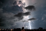
![]() mick Fri Oct 30, 2009 5:07 pm
mick Fri Oct 30, 2009 5:07 pm
 [/img]
An hour or so old but promising.
mick- Posts : 149
Join date : 2009-06-30
Location : down the bay
Re: Victoria: Thunderstorm Outbreak. October 28th-November 3rd 2009
![]() James Fri Oct 30, 2009 5:08 pm
James Fri Oct 30, 2009 5:08 pm
cicadas are out in full force, its deafening
Last edited by James on Fri Oct 30, 2009 5:11 pm; edited 1 time in total
James- Posts : 94
Join date : 2009-06-13
Location : Boronia
Re: Victoria: Thunderstorm Outbreak. October 28th-November 3rd 2009
![]() Power Storm Fri Oct 30, 2009 5:10 pm
Power Storm Fri Oct 30, 2009 5:10 pm
Had been watching this cell on the radar whilst on the bus, but when I got home I realised the BoM had issued the STW for my area, so I checked models etc... radar/SAT confirmed the storms were growing and moving SE towards me!!! Started off really black to my west, you could see some of the Cb but there was cloud obscuring the view, however I have a great video of all of it which I will post on youtube etc... later. Lightning was absolutley amazing, heaps of CG's and flangs and the rain, was sooooooo heavy! Localised flooding around too. Winds also got strong in it and we had a power outage. There was also a small fire started in plantation just next to our farm, however its out now. But the video explains it all better than what I could. I am going to check the rain gauge soon to see how much we got.
OMG.... latest radar looks like its back-building, and just checked the skies out west and magnificent, more convection just developing to my WNW.... I think I might be in for round 2 soon! More heavy rain as well..... We shall see.
Looks as if there could be some developing storms over the bay atm.
Last edited by Power Storm on Fri Oct 30, 2009 5:13 pm; edited 1 time in total
Power Storm- Posts : 703
Join date : 2009-05-18
Age : 30
Location : Simpson South -
Re: Victoria: Thunderstorm Outbreak. October 28th-November 3rd 2009
![]() Karl Lijnders Fri Oct 30, 2009 5:10 pm
Karl Lijnders Fri Oct 30, 2009 5:10 pm
The satellite image is important there. If you note the sharpness of the anvil on the western flank, this gives you an indication that there is still strong support and fresh convection happening within the complex given the radar images now and that the image is an hour old, so regeneration is occuring.
Mid level showers and storms firing offshore, keep watching the radar, particularly in the outer SE and E suburbs in the next 2 hours.
Storms converging right over the Ballarat region so looking very promising for us here in Melbourne. Now we need the western suburb folk and western VIC folk to let us know what is happening on the lightning front!!!
Karl Lijnders- Posts : 1472
Join date : 2009-05-17
Age : 39
Location : Knoxfield, Victoria
Re: Victoria: Thunderstorm Outbreak. October 28th-November 3rd 2009
![]() Karl Lijnders Fri Oct 30, 2009 5:13 pm
Karl Lijnders Fri Oct 30, 2009 5:13 pm
This is getting quite exciting.
Karl Lijnders- Posts : 1472
Join date : 2009-05-17
Age : 39
Location : Knoxfield, Victoria
Re: Victoria: Thunderstorm Outbreak. October 28th-November 3rd 2009
![]() droughtbreaker Fri Oct 30, 2009 5:13 pm
droughtbreaker Fri Oct 30, 2009 5:13 pm
Getting a little excited at the latest radar image. Models indicating high instability levels to continue overnight seems to be on the mark at this stage. Once it gets dark enough I'll be able to report on what I can see to the west lightning wise.
droughtbreaker- Posts : 640
Join date : 2009-05-17
Age : 42
Location : Mount Macedon (520m asl)
Re: Victoria: Thunderstorm Outbreak. October 28th-November 3rd 2009
![]() Karl Lijnders Fri Oct 30, 2009 5:17 pm
Karl Lijnders Fri Oct 30, 2009 5:17 pm
Can also confirm rain curtain developing from convection to my WSW on my doorstep with nice inflow band.
Karl Lijnders- Posts : 1472
Join date : 2009-05-17
Age : 39
Location : Knoxfield, Victoria
Re: Victoria: Thunderstorm Outbreak. October 28th-November 3rd 2009
![]() Malleefarmer Fri Oct 30, 2009 5:20 pm
Malleefarmer Fri Oct 30, 2009 5:20 pm
Malleefarmer- Posts : 178
Join date : 2009-05-23
Re: Victoria: Thunderstorm Outbreak. October 28th-November 3rd 2009
![]() DC449 Fri Oct 30, 2009 5:22 pm
DC449 Fri Oct 30, 2009 5:22 pm
DC449- Posts : 156
Join date : 2009-06-13
Age : 30
Location : Melbourne SE
Re: Victoria: Thunderstorm Outbreak. October 28th-November 3rd 2009
![]() Bobman Fri Oct 30, 2009 5:22 pm
Bobman Fri Oct 30, 2009 5:22 pm
Bobman- Posts : 118
Join date : 2009-09-12
Age : 40
Location : Moorabbin
Re: Victoria: Thunderstorm Outbreak. October 28th-November 3rd 2009
![]() Flangfest Fri Oct 30, 2009 5:23 pm
Flangfest Fri Oct 30, 2009 5:23 pm
Flangfest- Posts : 23
Join date : 2009-05-18
Age : 33
Location : Knoxfield
Re: Victoria: Thunderstorm Outbreak. October 28th-November 3rd 2009
![]() hillybilly Fri Oct 30, 2009 5:23 pm
hillybilly Fri Oct 30, 2009 5:23 pm
BTW looking across the models ACCESS seems to have the best handle on things and hasn't changes in 3+ days. It got the convection today in the west and stalls the trough west of Melbourne tomorrow with a rainfall/storms foccusing on central/east central areas. It then brings the Monday low as an easterly low with heavy rain (like the EC scenario but a little further north).
BTW just got a BIG boom from the storm just south of us
hillybilly- Posts : 742
Join date : 2009-05-18
Location : Ferny Creek -
Sponsored content
Page 13 of 40 • 1 ... 8 ... 12, 13, 14 ... 26 ... 40 ![]()
» Victoria: (Possible) Low Pressure System and Thunderstorm Outbreak. October 4th-9th 2009
» Victoria: Rain and Thunderstorm event - August 28th to 31st 2009
» Victoria: Cold Outbreak. Series of Strong Cold Fronts. August 23rd - 28th 2009
» Victoria: Heatwave November 7th-12th 2009
|
|
|